


This is an archived article that was published on sltrib.com in 2010, and information in the article may be outdated. It is provided only for personal research purposes and may not be reprinted.
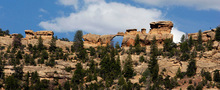
Range Creek Canyon • The first time Duncan Metcalfe toured this rugged canyon with Waldo Wilcox in 2002, the old rancher gestured toward a ridge atop the Roan Cliffs where a thin natural arch cracked the skyline like the eye of a giant needle embedded in the rock. Wilcox told his visitor he would find an ancient Indian settlement by Budge's Arch, named for Wilcox's dad.
Metcalfe, a University of Utah anthropologist and museum curator, dismissed the tale as an old-fashioned cowboy leg pull. Why would Fremont Indians inhabit a spot so far up the steep canyon walls from their source of food and water?
As it turned out, Wilcox wasn't pulling anyone's leg. Metcalfe's U. colleagues later explored the ridge and found what Wilcox said they would: remnants of Fremont dwellings.
Scientists now view Range Creek Canyon as a true archaeological treasure, believing it will provide clues to answer countless questions about American Indians who occupied the remote eastern Utah canyon in great numbers between 900 and 1200 AD. But the canyon, which is now in public hands, has been slow to yield its secrets, with little research published in peer-reviewed journals after several years of scientific scrutiny, partly because of funding shortages and management issues.
And control of the canyon recently was ceded to the U., raising questions about who will fill security and law enforcement roles previously provided by the Division of Wildlife Resources.
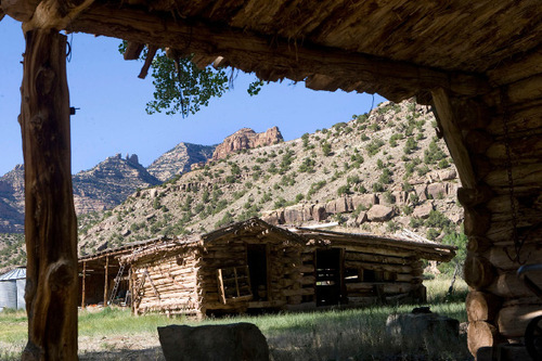
Range Creek became world famous in 2004 when the state announced it contained the richest concentration of undisturbed Fremont artifacts and archaeological features. A year earlier, Wilcox, who had controlled the canyon for more than half a century, sold his 1,500-acre ranch to the state of Utah, putting this treasure in public hands under the watchful eyes of DWR officers and university scientists.
To date, scholars have recorded 420 archaeological sites, and Metcalfe believes they have discovered only a fraction of what's there. Most habitations are found on rises above the creek's flood plain, but more are discovered every summer when students and faculty members comb the canyon and its dozen tributaries.
The ruins at Budge's Arch pose yet another mystery about Range Creek, framed by the Book Cliffs and the Tavaputs Plateau southeast of Price. The mystery deepened after geographer Larry Coats, a skilled rock climber, explored the top of a nearby 80-foot pinnacle. There he discovered defensive structures and rocks at the summit's edge, balanced on their side as if poised to be tumbled down on invaders.
"It was one of the last places I would have looked for an archaeological site," Metcalfe said while escorting visitors around the remote canyon where he oversees a U. field station. "There has to be an economic explanation. Under what circumstances does it make sense to live 900 feet off the valley floor?"
—
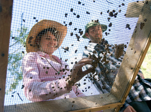
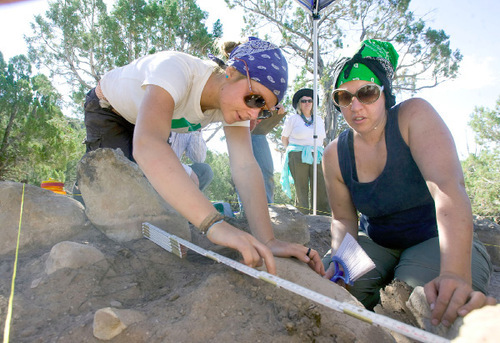
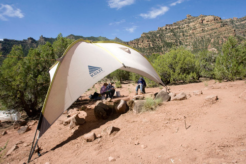
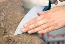
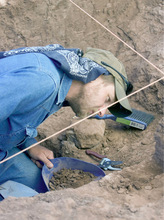
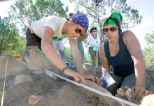
Training archaeologists • For the past eight summers, Metcalfe has brought a dozen undergraduate anthropology majors to Range Creek for three 10-day field sessions. Under the guidance of graduate students, participants conduct archaeological surveys and excavate trenches into suspected Fremont structures, meticulously removing the dirt one stratum at a time.
At one pithouse site (called Media, because that's where reporters were assembled for the 2004 announcement), Katie Thomas was puzzled by the strata, or lack thereof, her students were exposing within a 1-meter grid marked off with yellow cord.
"It started clean, then got jumbled with rocks. This stuff you can crumble out, while it's tougher here," Thomas said. Using a trowel and brush, student Maren Bodily removed the dirt and places it into a plastic paint bucket.
"This is as difficult stratigraphy as you're ever going to find. If you can figure this one out, the rest will be a cakewalk," Metcalfe told the students, pointing out the juniper roots that have coursed into the excavation zone and disturbed the dirt. The bugs weren't helping matters, so the students were burning juniper boughs in a coffee can nearby to keep them at bay.
After removing a layer of dirt, the students sifted it through 8-inch, then quarter-inch mesh in search of beads, animal bones, shards or anything that ancient inhabitants would have left. These finds were placed in plastic bags and precise locations were recorded. Metcalfe noted that much of archaeology field work is bookkeeping, with three people taking notes for every one moving dirt.
—
Mysteries abound • At the peak of the Fremont occupation in 1050, hundreds if not thousands of Indians lived in a canyon that could barely support one ranching family in the 20th century. The reason for such population density was agriculture. Growing maize allowed the Fremont to amass food, which they stored in granaries built on inaccessible ledges far above the canyon floor.
But how did the Fremont learn to grow crops and succeed in such inhospitable terrain? How did they interact with other Fremont bands and the Anasazi, a culturally distinct group that occupied the Four Corners region? And why did both groups, or at least signs of their presence, disappear in the 13th century?
Tantalizing clues crop up every year and scientists believe Range Creek will shed light on these and other Fremont mysteries, but not much science has been published. For Metcalfe, who usually performs field work in front of bulldozers, there is no rush.
"We have 30 years. Let's do all the groundwork, then do the analysis for the more rigorous results," he says. That groundwork includes a survey intended to identify the extent of the canyon's archaeological resource.
U. anthropologists have randomly selected 44 1-kilometer squares, or quadrats, representing 10 percent of the canyon, for careful inventory. In quadrats that can be walked, field-school students pace the length in 5-meter intervals, scanning the ground for artifacts with a GPS and camera in hand to record what they find. The survey is about one-third complete.
"It's not exciting, but it adds to a well-documented database we can mine for decades," Metcalfe says.
Lack of funding may be an obstacle: All of the U.'s Range Creek activities — security, road maintenance, the field station and research — are covered by a $337,000 state appropriation. It's not much, and three grant requests for federal research funding have been turned down.
Metcalfe said the requests were deemed too broad; more targeted proposals are being crafted.
Another obstacle to scientific discovery is requirements relating to human remains. Out of respect to the Ute Indians, who likely descended from the Fremont, scientists leave remains alone, even though they could reveal much about the health, diet and genetics of those who lived in Range Creek. When they discover bones, they record the location, notify the Bureau of Land Management or the state and move on.
Metcalfe hopes some day to win tribal permission to examine human bones, but in the meantime they are in no danger of being disturbed.
"This is the most protected canyon in Utah outside a national park," he says. And outlaw looters would not be interested in burial sites because they don't contain valuable artifacts, Metcalfe added.
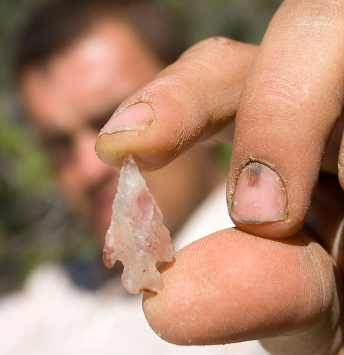
In fact, Range Creek has not yielded many intact artifacts. The handful of impressive ones that have been found include 11 figurines discovered in 1950 by rancher Clarence Pilling. More recently, priceless relics have been found cached in cracks in the sandstone: a wooden flute, a strange paddle-like object, a bundle of arrow shafts and a bundle of snares.
—
Tree rings and pollen grains • The nature of Fremont artifacts, which are notoriously hard to date, has further stymied scientific progress. Although a few studies are being reviewed for publication, the only one that has been printed was conducted by the Laboratory of Tree-Ring Research at the University of Arizona.
The study, whose authors include Renee Barlow, archaeology curator at Price's Prehistoric Museum, concludes that dendrochronology — the science of dating wood artifacts and reconstructing past climates from tree rings — may be of limited use in Range Creek because the Fremont built with wood types that do not lend themselves to tree-ring analysis. Freshly cut Douglas fir, a species that abounds in the canyon at upper elevations, would be great for dating, but the Fremont gathered nearby dead juniper, whose annual growth rings do not fluctuate the way pines do in response to dry and wet years.
Two ongoing studies advance theories about the canyon's most compelling mystery: granaries built in places nearly impossible to reach. These cliff-mounted structures posed technical challenges and extraordinary effort to build and maintain — hauling mud, water, wood, and rocks hundreds of feet up steep slopes and cliff faces — not to mention the risk of fatal falls when they were filled and emptied with maize.
One paper, authored by Barlow, describes the granaries as a passive defensive strategy that was abandoned as the Fremonts' settlement patterns changed. For another forthcoming study, U. graduate student Shannon Arnold Boomgarden is conducting a spatial analysis to argue that the Fremont deliberately located granaries to maximize their visibility. She theorizes this strategy ensured a potential thief could not approach the granaries without being seen.
Another U. group, the department of geography's Records of Environment and Disturbance, better known as the RED lab, is pulling sediment cores out of bogs and picking apart pack rat middens, ancient piles of debris the rats gathered and glued together with urine. The geographers extract tiny pollen grains from the samples and examine them under microscopes to determine what was growing nearby. Radiocarbon technology can date these materials to within 50 years, so the goal is to pinpoint when maize was cultivated in the canyon and to reconstruct a record of vegetation.
Other scholars are deploying new technologies to source and date pigments used in rock art and clay used in pot making. Range Creek pottery was tempered with basalt, a volcanic rock that does not occur here, Boomgarden says.
—
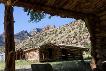
The Wilcox Ranch • During field school, Metcalfe's students congregated down canyon every evening at the old Wilcox ranch nestled along the creek under a dreamy cottonwood grove. They ate dinner prepared by field station manager Corinne Springer, herself a trained archaeologist studying native plants the Fremont may have used, such as coyote tobacco.
Tonight, Metcalfe enjoys a cigarette as a full moon peaks over the Roan Cliffs, relieved another day has gone by without his worst fears materializing.
"It's my job to worry," he says, concerned that students could get hurt in a fall or suffer heat exhaustion. Help is far away, but his graduate assistants are all certified wilderness first responders. His anxiety turns to marvel as he describes the ingenuity of the Fremont and Waldo Wilcox, who now lives in Green River, to persevere in such a harsh environment. The rancher, renowned for his crotchety attitude toward those he deemed "hippies," left his own archaeological record of improvised fixes, like the diversion dam he built with ore cars. Waterways weren't the only thing he manipulated.
The canyon's noteworthy but elusive residents include two bison believed to have migrated from tribal lands to the south. Wilcox claimed to have once roped the bison — there were three of them, Metcalfe said the rancher had told him — and castrated them.
"He didn't want them breeding with his cattle," Metcalfe says. "I believe him. Waldo has never lied to me."
If you go
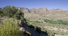
Range Creek Canyon is a remote pocket of Utah covering the 50,000-acre drainage of a Green River tributary. The area is known for 900-year-old remains of a Fremont Indian occupation, but visitors should expect to see cliff dwellings and other spectacular ruins associated with the Anasazi. Range Creek's archaeological resources are largely out of sight for those who don't know what to look for and where to look. You can stare at a granary and still not see it, and visitors have unknowingly walked over pithouse sites.
Remoteness • No cell phone coverage or services of any kind, hiking trails or interpretive signage, just a narrow 12-mile road from the north entrance down canyon to the Wilcox Ranch, where the University of Utah runs an archaeology field school.
Access • Via an 8,700-foot pass on a rugged 8-mile dirt road (impassible in wet weather), at least a two-hour drive southeast out of Price. The road goes up Horse Canyon and down Little Horse Canyon to the confluence with Range Creek, where a locked gate marks the north entrance. This is where the general public can enter on foot.
Camping • Permitted but there is no drinking water or other amenities except a flat clearing by some cottonwoods and two portable toilets.
Visitation • Entry is limited to just 28 people, either on foot or horseback, each day. However, that cap is rarely reached and does not apply to those who employ one of the four commercial tour operators.
Season • Runs from April 15, depending on the arrival of spring, through Dec. 1. Be sure to bring binoculars, good boots and lots of water, at least a gallon a day per person. Not many people visit. Permit visitation in 2009 amounted to only 330 hikers, far fewer than the 550 who entered in 2005, and another 312 visitors came with commercial tours.
Learn more • Or obtain permits, at umnh.utah.edu/rangecreek_home. —
Who were the Fremont?
Named after the Fremont River draining the southern part of their territory, these American Indians inhabited Utah centuries ago. This culture is distinct from the contemporaneous Ancestral Puebloans, or Anasazi, who left a more impressive archaeological record to the south. Unlike the Anasazi's elaborate cliff dwellings, the Fremont built pithouses that did not evolve much over the centuries. Anthropologists believe they subsisted on a shifting mix of hunting-gathering and agriculture. Cultivation of corn and squash allowed their numbers to climb between 700 and 1100 AD, to the point where they occupied much of Utah, while Anasazi culture flourished in the Four Corners region.
Both cultures appear to have gone into decline during the 12th and 13th centuries and left the region after a period of social upheaval, perhaps driven by climate change that made agriculture less tenable. Undisturbed artifact-rich areas like Range Creek may help scientists discover what happened.