


This is an archived article that was published on sltrib.com in 2015, and information in the article may be outdated. It is provided only for personal research purposes and may not be reprinted.
There's a new normal at the Great Salt Lake.
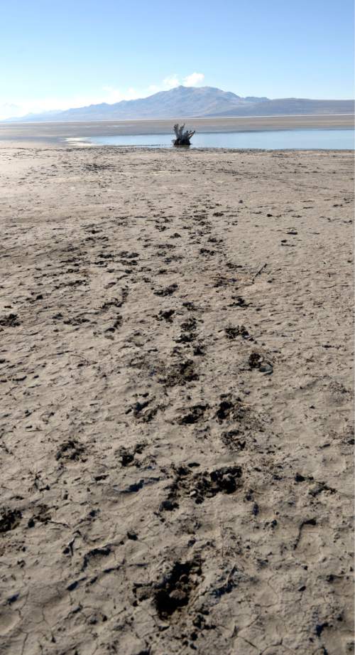
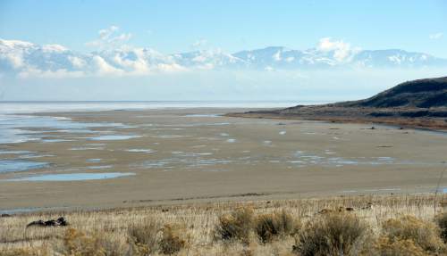
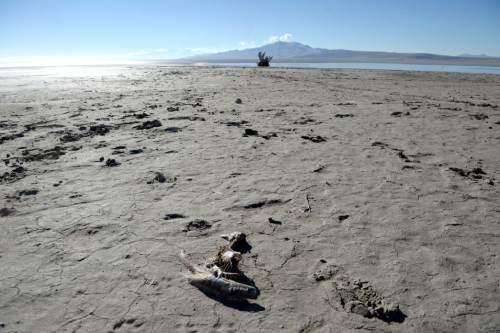
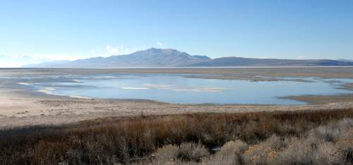
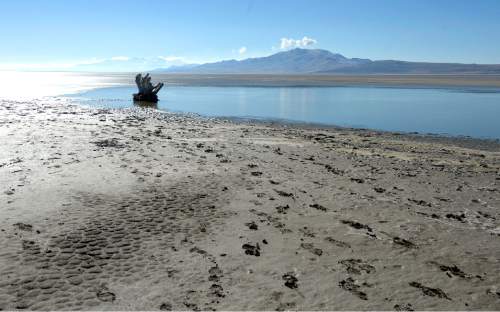
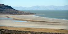
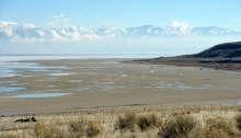
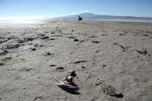
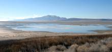
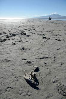
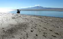
Hundreds of square miles of lakebed are exposed. Boat marinas are nearly landlocked. Islands have become peninsulas connected to the mainland. Salinity is rising in the south arm — endangering biodiversity and the brine shrimp and minerals industries. Water-sucking plants are growing on the shore. And mercury and other toxic metals normally trapped deep in the lower layers of the lake are swirling closer to the surface and drying into dust on the shore.
A combination of persistent drought and profligate use of water threatens to drive the lake level to a new low — shattering a record set more than 50 years ago.
Despite the lake's ecological and economic importance to Utah, surveys indicate few residents are interested in the inland sea — even those who live near the shore in Davis County. But with a $1.3 billion lake-dependent economy, wildlife habitat and clean water and air at stake, scientists warn Utahns cannot resort to conventional wisdom — and stories of the 1980s floods — to dismiss the signs of a lake in crisis.
An environmental catastrophe is not imminent for the Great Salt Lake. But if it is to be preserved as a functioning ecosystem, experts say, Utahns could face tough choices in coming years, particularly about their water use.
Leland Myers, who manages the Central Davis Sewer District, puts it this way: "I could have more habitat for birds, protection from dust storms and lake industries — or I could have more green lawn."
A decade of drought and diversions
For the past decade, the Great Salt Lake's water has hovered at chronically low levels after a prolonged dry spell and Utahns' unrestrained use of water.
During the nearly 160 years that records have been kept, the lake level has fluctuated about 20 feet — from a high of 4,211.6 feet above sea level in 1986 to the record low of 4,191.3 feet set in 1963.
Today the lake level sits at 4,193.8 feet at Saltair. Many observers expect it to dip to a new historic low within the year, depending on precipitation this winter.
"With all the diversions upstream and increased usage by mineral extraction, which is new, I don't see how we would avoid a new historic low," says Craig Miller, an engineer with the Utah Division of Water Resources.
State natural resources managers are struggling to plan for a terminal lake that generates $1.3 billion in economic activity and depends on water from a 33,000-square-mile basin drained by the Bear, Provo, Jordan and Weber rivers.
Scientists acknowledge the lake's level still will fluctuate, rising in a wet year or declining in a dry year, but it's unlikely the lake ever will reach that record high again — or the expensive, $60 million pumps installed after the floods of 1983.
The largest natural water mass west of the Mississippi is getting smaller. There's just too much water being diverted from the lake these days.
Decisions about upstream water use from as far away as Idaho will determine the future.
"It's evident we don't really have a good way of managing a low-level lake for the benefit of everyone. Our laws don't allow us to do a good job of that," Miller says. "We are going to have to do our homework."
As the Great Salt Lake shrivels, its level becomes even more sensitive to inflow changes from surrounding rivers. The surface area of the lake is now less than 1,000 square miles, a shadow of the 1,700-square-mile footprint at its historic average elevation of 4,200 feet.
There are other examples of American lakes starved of water.
"Owens Valley is the best example of what happens when you dry up a lake," says Myers, who also is chairman of the Great Salt Lake Advisory Council, invoking the memory of a California lake that was drained in the 1920s to fuel Los Angeles' meteoric growth, destroying a fertile valley in the process.
Utah's Sevier Lake near Delta, once 188 square miles, dried up in the 1880s as pioneers drained the Sevier River for irrigation. The lake bed near Delta is now simply dusty playa.
Other saltwater lakes around the world also are declining. Iran's Lake Urmia and the Aral Sea in Central Asia have been reduced by agricultural water diversions that raised salinity and doomed fisheries.
Evaporation is another big factor in the lake's water loss, but the rate slows as the lake recedes. A smaller surface area and higher salinity slow evaporation.
"It's a feedback mechanism that helps us out and resists shrinking as much as we think," says Wayne Wurtsbaugh, a professor of watershed sciences at Utah State University.
Helping prop up lake levels is a river's worth of wastewater discharged by Utah cities and industries — up to 200 million gallons a day, a volume on par with the proposed Bear River diversion. By some estimates, 90 percent of Utah's treated effluent is discharged near the lake. But Myers says some of that treated "gray water" may not even reach the lake, sucked up by thickets of phragmites, an invasive plant that is flourishing as the water recedes.
An unending cycle
With less water going into the lake every year, the shrinking trend is unlikely to change.
A series of wet years probably wouldn't be enough to rescue the lake, scientists say. Upstream reservoirs sit half empty. They would have to be filled before much of the spring runoff would reach the lake.
Meantime, driven by greater demand for water and the falling lake levels, industry and water agency managers are disinclined to cut the amount of water they siphon out of the lake and its tributaries.
According to a study Water Resources' Miller completed in 2008, upstream water diversions reduced the lake's volume by half, resulting in a level 11.5 feet lower than it otherwise would be. But he cautions that the study does not account for water withdrawals by lakeshore industries, which can range between 250,000 and 500,000 acre-feet, or Bear River diversions in Idaho. Miller is updating his data.
Meanwhile, more diversions are on the drawing board.
The 220,000-acre-foot Bear River project, which would develop culinary water for Salt Lake, Davis and Weber counties, would capture around 20 percent of the lake's most important water source.
Proponents estimate that the project would lower the lake level by around 6 inches.
Lake overseers have asked for more data. Myers and others want the state to take a deeper look at the impacts associated with diverting the Bear River so the public knows what's at stake if state leaders move forward on the long-stalled project.
"What does a half a foot mean? That could be half a mile of dry ground. Even six inches could be substantial for creating problematic conditions," he says. "At some point, you'll have enough beach out there that a windstorm could bring that beach into an urban area."
Meanwhile, shoreline extractive industries may ramp up water withdrawals, which they are entitled to take under water rights they have secured.
The companies are dredging canals to connect their intake pumps with the lake, which is moving farther and farther away from their operations.
Morton Salt, for example, has applied to dig a 10-foot-deep trench from its south shore plant an additional 1.8 miles to the water.
Brine shrimpers are dredging their harbor to maintain access for the boats.
Five companies extract salt, magnesium, potash and other minerals in massive evaporation ponds, producing 4.4 million tons a year valued at $685 million and supporting almost 2,000 jobs, according to a recent economic study.
All told, the lake supports $1.3 billion in annual economic activity — on par with the ski industry.
The lake economy includes recreation, such as boating, birding and hunting, and the winter harvest of brine shrimp eggs, worth about $34 million a year.
A sensitive habitat
Scientists and brine shrimp executives alike are monitoring how increasing Great Salt Lake salinity affects the brine flies, brine shrimp and myriad microbial organisms that make up the lake's intricate web of life.
The inland sea provides more than a third of the world's supply of the cysts, which aquaculture industries hatch into tiny shrimp and feed to fish and prawns.
At the same time, the lake sustains one of the West's crucial stopovers for migratory birds.
Up to 5 million phalarope, avocet, grebe, gull, ibis and other water birds — more than 200 species in all — visit the lake to nest, rest and feed during their seasonal journeys that take them as far as Argentina.
Near-surface salt concentrations in the lake's south arm have increased to around 17 percent — four to five times saltier than the ocean. And salinity on the north arm, which is isolated by a rock-filled rail causeway, is at the 28 percent saturation point.
A dense layer of high-saline brine also lurks on the south arm's lake bottom.
Scientists are concerned that surface salinity could reach levels that harm the lake's shrimp, depriving migratory birds of a critical food source and depressing the industry's egg harvests.
Brine shrimp can tolerate a wide range of salinity levels — somewhere between 3 percent and 28 percent, but prefer a 9 percent to 17 percent salinity range — while the algae species they prefer eating can handle a lot less variability.
Scientists worry that some organisms could die off as salts get more concentrated.
"Salinity is the driver of microbe diversity, the foundational organisms that are running the ecosystem of the lake. Salinity determines what is present in that community," says Bonnie Baxter, a biology professor who directs Westminster College's Great Salt Lake Institute. "Some algae make great food for brine shrimp and some make horrible food for brine shrimp. As we increase the salinity, we reduce biodiversity."
Nesting birds also are increasingly at risk as the water recedes.
The lake's smaller islands are becoming peninsulas and now can be reached by terrestrial predators like coyotes.
Gunnison Island is a breeding sanctuary for one of the top three populations of American white pelicans. Some 20,000 adults raise their young there each spring, but it is fast becoming less an island and more a hill on the lake's western shore.
A long-hidden mess
The retreating water is revealing a final threat: lingering heavy metals and toxic chemicals — selenium, mercury and arsenic — dumped into the lake over decades from natural and industrial sources, including Kennecott Copper.
Scientists fear the contracting lake could be concentrating and mobilizing the contaminants.
"This is drying up a lake that has been a historical dumping ground. Nothing leaves the lake but water," Baxter says. "Everything that has gone in is still there."
The toxic metals are present in the lake bed, the water and the food chain. Eating advisories are already in place for three species of waterfowl enjoyed by hunters.
Some scientists are concerned the low lake could help methylate mercury, a biochemical process that transforms this pollution from its elemental state to a neurotoxin that accumulates in living tissue. They wonder if the methylmercury, which has been produced by anaerobic bacteria and trapped in the lake's so-called "deep brine" layer, could move upward.
The low lake level might enable wave action to disturb the dense brine layer and mix it with the upper layers, where it could harm wildlife, according to David Naftz of the U.S. Geological Survey. The latest monitoring data, however, indicate near-surface mercury levels remain well below federal thresholds for aquatic wildlife, according to the Utah Division of Water Quality.
But there are other mercury concerns.
"Now we have dry lake beds," Naftz says, "and if they resaturate, what is that going to do to the mercury budget in the lake?"
The newly exposed metals also could harm the human population around the lake.
The legacy of a declining lake, observers say, is likely to linger for decades.
In the Owens Valley, dust storms have shut down U.S. Highway 395 and triggered health advisories in communities across the valley. Migratory bird populations declined. And more than 20 years ago, the U.S. Environmental Protection Agency ordered Los Angeles to restore the valley in a fight that has dragged through the courts.
In Utah, conservationists hope to avoid that kind of catastrophe.
"What is Utah willing to do to preserve the quality of life and make way for growth spurts?" asks Lynn de Freitas, executive director of Friends of Great Salt Lake. "There is a stigma in some circles over the conservation of water. Does it mean things dry up and lawns turn brown?
"We have to look realistically at the future," she says, "so that we can sustain things that draw people to Utah and keep people here."
A lasting solution, conservationists say, will require Utah farmers and residents to curb their appetites for water. Let just a little more reach the lake.
bmaffly@sltrib.com Twitter: @brianmaffly —
Coming Monday
The state of Utah and Union Pacific Railroad might have a solution for a damaged causeway that is cutting off water circulation at the northern end of the Great Salt Lake.