
This is an archived article that was published on sltrib.com in 2017, and information in the article may be outdated. It is provided only for personal research purposes and may not be reprinted.
San Juan County leaders are still fuming over last week's Bears Ears National Monument designation, but the outgoing Obama administration did leave one parting gift for the county's ATV riders.
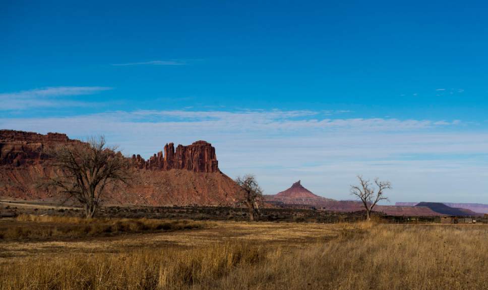
Last month, the Bureau of Land Management approved a 6.4-mile motorized route in Indian Creek, which the county has long sought a right of way for. Motorized enthusiasts want the trail — near the entrance to Canyonlands National Park's Needles District — to bridge popular riding areas on either side of State Route 211.
John Fellmeth and other county officials are incensed that the BLM took so long to approve a route that largely parallels established roads.
"The environmental groups made an issue of it when it shouldn't have been an issue," said Fellmeth, a past president of the motorized group known as SPEAR, or San Juan Public Entry and Access Rights. "The real issue is BLM's inability to follow their own guidelines and process a right-of-way application. They have 60 days. There is no rational basis for it take longer than 10 years."
Environmental groups contend the trail is not only "redundant" and "superfluous," but will also invite greater motorized use in places where it doesn't belong and penetrate wilderness-quality land. They are contemplating appealing the decision signed Dec. 14 by the BLM's Monticello field office manager, Don Hoffheins.
"The new ATV route would unquestionably impact the naturalness of the area as well as the quiet, wilderness experience that can be enjoyed there today. In addition, the new ATV route would be a significant conflict with other nonmotorized recreational uses of the area, including its famous rock-climbing opportunities," wrote Neal Clark, a staff attorney for the Southern Utah Wilderness Alliance, in a blog post.
The group has lobbied against the route since the right of way was first proposed in 2006 and convinced the BLM to revise its environmental assessment three times.
In this last version, Hoffheins concluded the trail aligns with the field office's resource management plan to "sustain a wide range of recreation opportunities and potential experiences for visitors and residents while supporting local economic stability." The agency found that the trail would increase traffic only slightly and could actually minimize ecological damage by encouraging existing motorized users to adhere to a designated route and parking areas.
"This is not a realistic assumption," wrote the National Parks Conservation Association in its comments to the assessment. "ATV enthusiasts will be drawn to the area adjacent to Canyonlands National Park in greater numbers, ATV use will indeed increase, and the natural and cultural resources of Canyonlands National Park is likely to be impacted."
This concern was echoed in the National Park Services' own comments, which stressed the possibility of greater ATV use in Davis and Lavender canyons and illegal motorized incursions into Canyonlands.
Hoffheins did decline to grant a right of way. Federal law allows such a right across public lands if the route is part of a "necessary" transportation system.
The BLM agreed to widen the trail from 60 to 65 inches to accommodate UTVs, the increasingly popular "utility task vehicles" built for side-by-side riders. Constructed and maintained by the BLM in collaboration with the county, the trail will pass near the Hamburger Rock and Creek Pasture campgrounds just north of State Route 211 through the scenic Indian Creek Canyon, renown for its Wingate Sandstone cliffs revered by rock climbers around the world.
The approved alignment also passes through the historic Dugout Ranch.
"To heck with my pastures, what worried me most was the likelihood of erosion," rancher Heidi Redd said. "This piece slants from the highway down to Indian Creek. It can easily be eroded if we get big rainstorms and we have an ATV trail cutting across it."
She believes the trail should have been routed along the highway.
The trail may seem like a minor project, but the debate highlights the rancor between Utah environmental community and San Juan County. Both sides claim the BLM is illegally "caving" to pressure from the other side.
This proposal has dragged on even longer than San Juan's right of way application through Recapture Canyon east of Blanding, which has been closed to motorized use for a decade thanks to unauthorized trail construction. Years of delay is what prompted the 2014 protest ride that led to the conviction of County Commissioner Phil Lyman on charges of conspiracy and driving in an area closed to motorized use.
In September, the BLM released a draft environmental assessment for the proposed 12-mile trail network in the canyon, home to numerous cliff dwellings and other archaeological resources, and a final decision is due soon.
The Indian Creek trail has been hung up largely because of successful challenges to the BLM's past analyses brought by SUWA, the Sierra Club, Grand Canyon Trust and Great Old Broads for Wilderness. Most recently in 2015, the Interior Board of Land Appeals vacated approval for the trail after the BLM conceded more analysis was needed.
Now the groups are dismayed that the BLM did not allow an opportunity for public comment and suspect the agency rushed to establish the route before the Bears Ears' long-anticipated monument designation, which occurred Dec. 28.
About 2,800 mile of motorized routes are available in San Juan County, but local officials say this stretch is needed to tie together Trail 1, a 400-mile loop circumnavigating the county.
"It's kind of an ATV adventure, a multi-day trek where you need to cache water and food in certain places," Fellmeth said. "It's legitimate way for people who are unable, physically disabled, to go out and see iconic scenery on existing roads and trails."
Brian Maffly covers public lands for The Salt Lake Tribune. Brian Maffly can be reached at bmaffly@sltrib.com or 801-257-8713.
Twitter: @brianmaffly