

This is an archived article that was published on sltrib.com in 2011, and information in the article may be outdated. It is provided only for personal research purposes and may not be reprinted.
Water and weather experts are fairly certain that five to seven consecutive days of high temperatures will bring widespread flooding. Less predictable, however, are mudslides and debris flows that can swallow roadways and structures with little warning.
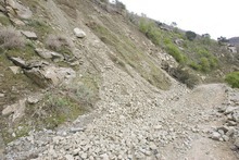
The spate of landslides reported since Saturday after heavy rains in northern Utah is an unsettling reminder that flood season in the mountains is precarious in more ways than one. And with each passing day, the time frame for melting record amounts of snow at high elevations becomes more compressed.
If temperatures suddenly rose to normal — or above normal — creeks and rivers in much of Utah would jump their banks, according to Brian McInerney, a hydrologist for the National Weather Service.
That most likely would lead to more mudslides, too, said Rich Giraud, senior geologist with the Utah Geological Survey.
The average high temperature for valley locations in northern Utah during the first week of June is 82 degrees. But the forecast for the next five to seven days calls for relatively cool temperatures, according to the weather service, with highs ranging from 60 degrees to the mid-70s. Rain showers Tuesday should give way to partly cloudy skies for the remainder of the week.
A string of days with average to high temperatures could result in a quick melt that would continue to soak and destabilize already saturated soils, particularly on steep slopes, Giraud said.
"You really can't forecast landslides. In terms of timing, we can't do that," he said. "But when we have above-normal precipitation and a lot of snowmelt, the potential increases. If it warms up, we may start to see a lot of landslides."
Davis County, with its steep canyons, has had a history of mudslides and debris flows, including a number in 1983, a year remembered for widespread flooding, Giraud said.
In May of that year, the snowpack above Farmington Canyon held 57 inches of water, he said. A sudden warm-up at the end of the month led to 35 days of intense melting and several dramatic debris flows that damaged homes, roads and other infrastructure.
This year, 61 inches of water still remain in the snowpack above Davis County.
Gigi Madsen remembers the night of May 30, 1983, when a wall of mud washed down Stone Creek above Bountiful and slammed into her home.
"It was a 20-foot wall of mud. The house was hit and torn off the foundation," she said. "We heard a sound like an earthquake, and the house shook."
The Madsens escaped uninjured but had to rebuild their house.
Planning for the unpredictable is difficult, said Dave Millheim, Farmington's city manager.
"We're nervous," he said. "Mudslides don't give you much warning."
He recalled a debris flow several years ago that destroyed nine houses in Rudd Canyon east of Farmington.
Millheim is advising residents living on hillsides or near creeks to avoid sleeping in basements until the runoff season is over. "We're just saying use caution and common sense," he said.
Farmington, along with other municipalities along the Wasatch Front, is as prepared as it can get for flood season, Millheim said. Since 1983, many catch basins have been built in drainages to stop debris flows.
"But you can't build a debris basin big enough to hold a whole mountain if it decides to go," he said.
Giraud said mudslide risk increases when runoff is equivalent to 1 inch or more of water per day, which happened in 1983 and last spring.
"But if June stays cool and we don't see a fast melt, we might not see a lot of landslides," he said.
However, if temperatures spike as they did last June, runoff could be even greater than in 2010 or 1983, McInerney warned. Water rushing off mountains could reach the equivalent of 3 to 4 inches of water per day over a prolonged period.
"The more we delay [warming temperatures] the more nervous I get about the flooding we're going to see," he said.
Mudslides since May 21
Ogden Canyon, State Route 139
Farmington Canyon road
Tooele Valley, State Route 199
Beaver Canyon, State Route 153
Santaquin Canyon road —
More online
Find more information on the threat of spring flooding. › sltrib.com/topics/utflood