


This is an archived article that was published on sltrib.com in 2011, and information in the article may be outdated. It is provided only for personal research purposes and may not be reprinted.
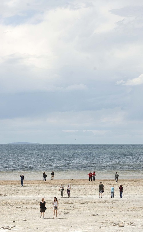
The Great Salt Lake is about to make a historic leap.
The lake level will rise by as much as 5.7 feet — a one-year record — by the time the snowpack melts in northern Utah mountains. And the lake's surface area will expand by almost 40 percent, according to state water officials.
That will be good for wildlife, fantastic for sailboat enthusiasts and it might please skiers, too — setting the stage for more lake-effect snowstorms.
But one of the lake's most famous man-made features — the Spiral Jetty — will be submerged.
In mid-November, the lake level sat at 4,194.5 feet in elevation. That's very close to the modern-era low of 4,191.3 feet, recorded in 1963, according to the U.S. Geological Survey.
As of June 7, the lake had come up to 4,198.1 feet and is expected to hit 4,200 feet or more by the end of the snowmelt. A 5.5- to 5.7-foot gain would be the biggest in one year since records have been kept, according to Dave Shearer, the harbor master at the Great Salt Lake State Marina.
During the previous wettest years on record, the lake rose 4.5 feet in 1983 and repeated that performance in 1984, according to state records.
But the water has been so low that this year's huge runoff will bring it only to its historic average. The lake would have to come up another 6 to 8 feet before the pumps on its west shores, installed by Gov. Norm Bangerter in 1987, could be turned on, said Todd Adams of the state Division of Water Resources.
In 1986 and 1987, the lake hit 4,212 feet — a modern-era high. Its surface expanded to about 2 million acres and resulted in flooding of properties and businesses along its shores.
But this year, the lake won't get high enough to cause major negative impacts, according to Adams.
And while agricultural interests are suffering from high water along the Weber and Sevier rivers, among other places, sailors on the Great Salt Lake are ecstatic about the runoff. The lake has been so low that sailboats were stuck in the harbor for much of the year, Shearer said.
"We are almost going to recoup from our 11-year drought in one winter," said Shearer. "The last few years has sucked the life out of the marina. But it's coming back to life. This has bought us a couple of years of sailing."
Typically, the lake will rise about 2 feet each spring through runoff from the Bear, Weber and Jordan rivers. It then falls by about 2 feet throughout the summer from evaporation, Shearer explained. But for the past several years, it's been rising by less than 2 feet in the spring and dropping by more than 2 feet in the summer.
The rising water also is good for wildlife, particularly bird populations that nest or molt on the lake's shores. The Great Salt Lake is part of both the Pacific and Central North American flyways and hosts hundreds of bird species and populations that number in the millions, said John Luft of the state Division of Wildlife Resources.
Among other things, the rising water "pushes salinity" into areas that have been invaded by non-native grass species. The salty water kills the non-native species and revitalizes the habitat, he said.
A second benefit of a higher lake elevation is that it swamps land bridges to islands exposed when the water was low. Land passages to Hat and Gunnison islands allow predators, such as coyotes, to invade bird nests and seriously disrupt populations, Luft said.
The Great Salt Lake is always in flux because it has no outlet, said Phil Douglass, DWR's northern region conservation and outreach manager. It fluctuates from year to year and month to month.
"The shoreline of the Great Salt Lake is transitory in nature," he said. "It rises and it falls. That creates different habitats at different times of the year."
As the water comes back to its historic average, no great impact is anticipated on lakeside industries.
For example, Great Salt Lake Minerals, a company that produces sulfate of potash for agriculture, doesn't foresee problems, said spokesman Dave Hyams. "It's back to normal," he said.
And although lake water will cover beaches that have been exposed for the past decade, the rising water won't dramatically reduce wind-blown dust, said Dave McNeil, environmental program manager for the state Division of Air Quality.
"The Great Salt Lake contains magnesium chloride that, when dried, creates a hard crust,"he said. "It does a very good job of stabilizing the lake bed."
Because the remnant of ancient Lake Bonneville is shallow, hitting depths of only 40 feet, large influxes of water greatly expand its surface area.
Last fall, the lake's surface area was about 661,000 acres. When it reaches 4,200 feet, it will encompass about 1 million acres, according to the Division of Water Resources.
And that may help generate more lake-effect snowstorms, said Christine Kruse, a meteorologist for the National Weather Service.
The phenomenon occurs when cold winter wind streams across the relatively warm waters of the Great Salt Lake, Kruse said. Under the right conditions, a larger lake could mean an increase in snowfall.
While industry, wildlife and recreation specialists watch the lake rise and fall each year, Lynn de Freitas of Friends of Great Salt Lake worries more about the long term.
"The future of the lake is going to be a tough one," she said. "We will see a trend toward lower levels [because] there will be more development and a greater capacity to use the water" before it reaches the lake.
Great Salt Lake facts
Largest U.S. lake west of the Mississippi
About 75 miles long and 28 miles wide
Three to five times saltier than the ocean
One of the largest migratory bird stopovers in North America
No fish live in its briny waters
Source • U.S. Geological Survey —
Ups and downs
The level of the Great Salt Lake fluctuates constantly because it is landlocked. Some notable years:
Modern-era low • 4,191.3 feet in 1963
Modern-era high • 4,212 feet in 1987
Current level • 4,198.1 feet on June 7
Forecast high, 2011 • 4,200 feet