
This is an archived article that was published on sltrib.com in 2011, and information in the article may be outdated. It is provided only for personal research purposes and may not be reprinted.
Forecasting a flood is no easy task.
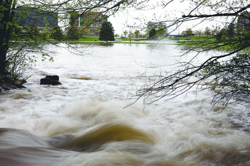
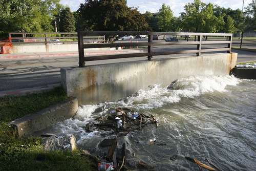
Little Cottonwood Creek was expected to jump beyond flood stage by the early morning hours Friday. But that forecast was revised by the National Weather Service, which said the flooding wouldn't hit until Saturday.
Then they changed it again.
At around 7 p.m. Thursday, the creek was above flood stage of 800 cubic feet per second. The last measurement at 11 p.m. showed the water surging at 863 cfs, just below where it was at 9 p.m. It was expected to hit 1,000 cfs between midnight and 1 a.m., but instead crested just before midnight, the National Weather Service said. There were no reports of property damage or street flooding at midnight, according to Scott Baird, Salt Lake County flood control director.
Police closed Murray Park at 10 p.m. as a precaution.
That change illustrates the difficulty in predicting runoff in a year that broke records.
For the past three months, Utahns living along rivers and creeks have been riveted by National Weather Service forecasts of when and how high waterways would rise.
There's a lot at stake: crops and livestock, roads and bridges, barns and houses, and even lives.
But how does the weather service know, for example, that Little Cottonwood Creek will rise from a flow of 600 cfs at noon Friday to 900 cfs Saturday morning at 1 a.m.?
It's actually an interagency effort, with the weather service borrowing mathematical models devised by the Colorado Basin Forecast Center and data collected by the Natural Resources Conservation Service. Forecasters factor in the amount of snow, the water in the snow, the air temperature, the soil temperature, and the soil moisture and voilà.
But it's a lot more complicated than that, said Brian McInerney, hydrologist for the weather service in Salt Lake City.
"People think it comes out of a black box. But we have a lot of variables that can't be quantified," he said, "And in any forecast, there are errors."
In fact, this spring the weather service has fairly accurately predicted flooding along various rivers in northern Utah.
But late Wednesday and early Thursday, Little Cottonwood Creek did not rise as much as expected, leaving McInerney and his colleagues scratching their heads. So they began re-evaluating the models and the data used in the forecast.
Those models — mathematical formulas developed by the Colorado Basin Forecast Center — consider topography and sun exposure, as well as elevation and even evaporation.
The Colorado center develops models for some 500 drainage systems in Colorado, Utah, Arizona and parts of New Mexico, said Craig Peterson, a hydro-meteorologist. Those models have been refined over a 30-year period.
Forecasters compare their predictions to what actually occurs and make "calibrations," he said. The models are based, in part, on what has occurred in past years.
"This year tested those models. We had extreme precipitation and a late snowmelt," he said. "It challenges the model to predict during a regime that we've never seen before."
At the heart of stream-flow forecasting are data collected by the Natural Resources Conservation Service (NRCS) through the Utah Snow Survey. That data are gathered by instruments called "snotels" that measure snow depth, water in the snow, soil moisture and soil temperature, said Randy Julander, snow survey supervisor for NRCS.
There are 105 such devices throughout Utah that annually collect 15 million pieces of data.
But there is only one snotel in Big Cottonwood Canyon and one in Little Cottonwood Canyon. And those stations present two entirely different views of the remaining snowpack. The snotel at Snowbird in Little Cottonwood Canyon shows 45 inches of water in the remaining snow. But the snotel at Brighton shows only 6 inches.
The location of the snotel in Little Cottonwood Canyon, where snows are deeper than on south-facing slopes, was a factor in the original June 22 forecast for Little Cottonwood Creek that had to be revised, McInerney said.
One reason for the discrepancy is that the Little Cottonwood device sits at 9,640 feet elevation on a north-facing slope, while the Big Cottonwood snotel is at 8,750 feet on a south-facing aspect.
"It highlights the need we have to have more than one in each basin," said Julander. But the instruments cost $25,000 each.
Forecasting river flows is a "difficult job," McInerney said. "But there are a lot of intelligent people working on this 24 hours a day."
Tribune reporter Jason Bergreen contributed to this story.
More online
Read more about spring flooding • http://www.sltrib.com/topics/utflood —
Houses swamped in Gunnison
The overflowing Sanpitch River on Thursday flooded some homes in Gunnison.
Jeff and Lynette Piep and Ashley and Chas Edwards were fighting back intruding water from the swollen Sanpitch, which flows just yards away from their neighborhood.
"This has been a mess. It's ridiculous. It's frustrating," Lynette Piep said Thursday night.
Water is seeping through the basements of both homes despite preventive measures Gunnison City took several weeks ago to keep the river contained.
"The sandbags don't do a bit of good," Lynette Piep said.
Jeff Piep knocked holes in their basement's concrete floor and installed pumps. One of them keeps up with the inflow; the other one almost does.
"It's like a stream under our house. It's like a little brook," Lynette Piep said.
The Edwardses have also installed pumps, and even dug a mote-like trench around their house to keep water at bay.
Downstream, a great deal of farmland has also been flooded, ruining some crop fields for possibly the entire summer and making other pastures unusable.
The Sanpitch River was expected to peak Thursday night and Friday morning, said Garn Nelson, the water master of a local irrigation company.
John Hales