


This is an archived article that was published on sltrib.com in 2013, and information in the article may be outdated. It is provided only for personal research purposes and may not be reprinted.
The Bureau of Land Management is evaluating safety options after Monday's fatality brought to three the number of people who have died hiking this month near The Wave rock formation, known worldwide for its scooped-out valleys of vibrant sandstone.
Among the wide range of options being considered: adding trail markers, boosting cellular phone coverage, increasing access permits, and, contrarily, periodically closing the wilderness area to visitors altogether. But there is no set timetable for change, and hikers will still bear responsibility for their own safety.
"It is going to be a rugged, remote location," warned BLM public affairs officer Rachel Tueller. "There's still always going to be a need to prepare."
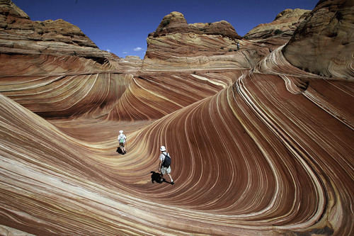
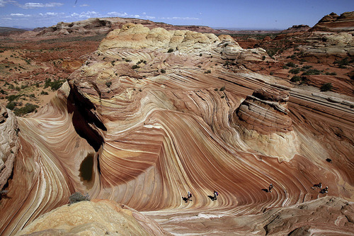
The striped, undulating slopes of The Wave resemble a stormy sea, with walls that look like clay suspended in motion on a potter's wheel. A natural draw for photographers, the remote section of Vermilion Cliffs National Monument was relatively obscure until it gained widespread popularity over the last 10 to 15 years, said Kane County Sheriff's chief deputy Tracy Glover. Last year saw more than 48,000 people apply for just 7,300 permits to hike to the formation on a 6-mile round trip that begins in Utah and ends in Arizona.
"The unusual thing about The Wave is it's a destination within a wilderness area, so there's limited resources," Glover said. "It's also an area that's kind of a bucket list item, for lack of a better term, and some of the folks are not avid hikers."
Glover said that online reviews often bill the hike as undemanding, but "what's easy for you isn't necessarily easy for me."
The terrain is fairly exposed to the elements, people must traipse through deep sand at times, and there is no formal trail. The nearest emergency resources — in Page, Ariz., and Kanab — are more than 45 miles away. And while efforts are made to keep visitors safe, BLM's central mission in the wilderness area is stewardship of the land.
On Monday, 27-year-old mother of two Elisabeth Ann Bervel died while hiking with her husband on their fifth wedding anniversary, less than a month after Ulrich and Patricia Wahli — 70 and 69, respectively — died of heat exhaustion as temperatures exceeded 100 degrees.
A sheriff's office news release says the Bervels, from Mesa, Ariz., began the trek at 8 a.m. They lost the trail on the return leg during peak temperatures before Elisabeth Berval grew tired and collapsed. Anthony Bervel, who had applied for the permit with his wife for three consecutive years, hiked into cellphone range and called authorities, but medics flying from Page found the woman in cardiac arrest and were unable to revive her.
"In interviewing [Anthony], he was fairly confident that they knew what they were doing," Glover said. "They were prepared."
Oddly, Monday wasn't a particularly hot July day by southern Utah desert standards, Glover said, though perhaps it was a little bit more humid than usual. Nonetheless, Glover said the sheriff's office believes the medical examiner will find that the cause of death was related to the heat.
On July 4, the Wahlis, of Campbell, Calif., were found dead in a similarly harrowing scenario — Ulrich Wahli 250 yards away from his wife, who had apparently stopped to rest under a tree.
Glover and BLM officials were only aware of one other fatality in The Wave's recent history, when a hiker fell from a canyon rim after becoming lost at night in July 2011, but Glover said people frequently lose their way and require assistance.
"We have a few close calls," he said. "In particular, from people who are more interested in carrying their camera equipment than the appropriate supplies."
The Bureau of Land Management recommends a gallon of water per person, salty snacks and sunscreen. Many hikers opt to go it alone (though professional guides are available), but permits come with a map that includes compass points and photos of key navigational points. To get an online permit, hikers must first watch a safety video, and 10 daily "walk-in" permits mandate a 24-hour wait for visitors to study up. The BLM also added a volunteer safety patrol in 2012 to carry water and provide assistance to hikers, though "it shouldn't be relied upon," Tueller said. "It's sporadic."
But since those standards didn't prevent the recent tragedies, BLM officials are asking how they can do more.
Managers from three BLM offices are involved in the safety discussions, and Tueller said a third-party review may also be conducted.
Glover said he is aware of some of the options on the table, and he has shared his own thoughts. "I would like to see some trail markers added, and I've expressed that to the BLM," Glover said, adding that, "It'd be great in my opinion if we could enhance cellular telephone coverage in that area."
Glover said the BLM is also considering increasing the permit total (people on the trail often help each other stay on course) and that there is talk of closing the park altogether for stretches. Tueller thinks closures are probably unlikely because the trailhead provides access to other popular areas like Buckskin Gulch and there is no telling when extreme heat will come.
It was actually hotter on July 4 than July 22 this year, for instance. "It would be a guessing game," she said.
Twitter: @matthew_piper