

This is an archived article that was published on sltrib.com in 2016, and information in the article may be outdated. It is provided only for personal research purposes and may not be reprinted.
Utah's water supply is feeling the heat — literally — as it enters the snow accumulation season.
October temperatures averaged 5.3 degrees higher than normal, said Brian McInerney, a hydrologist for the National Weather Service in Salt Lake City. As a result, Utah's snowpack is already lagging, according to November's monthly Utah Climate and Water Report by the Natural Resources Conservation Service.
According to the report, precipitation totals ranged from 197 percent of normal in the Bear River basin, to 21 percent of normal on the Lower Sevier River. The Provo-Utah-Jordan river basin, which surrounds both Provo and Salt Lake City, received 87 percent of its normal precipitation.
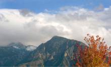
At higher elevations, some of that precipitation did arrive in the form of snow. But elevated temperatures caused most of this snow to melt quickly.
This has been a boon to stream flows and soil moisture levels, according to the report, but could spell trouble for the state's reservoirs, which rely on winter snowpack and the resulting spring runoff to refill each year.
Reservoir storage is currently at 46 percent, meaning Utah needs a wet, snowy winter if those reserves are going to return to full capacity next year.
"This is the sixth year that we've started off in a poor fashion," McInerney said. "We really don't need this right now. What we need are more storms."
McInerney said the past month's heat is the result of the same recurring weather pattern that is responsible for the state's now six-year-old drought. Since fall 2011, he said, a ridge of high pressure has come to dominate Utah's winter weather, which prevents cold, stormy weather from reaching the state.
While it's still early in the season, the fact that the ridge has returned has state hydrologists on edge, McInerney said.
"All of these are ominous signs," he said.
Even if Utah starts the season with little snowpack, McInerney said it's possible for the state to recover later in the year. But if snowpack doesn't start building by December, he said, the odds of a amassing a healthy snowpack this winter become slim.
The National Weather Service expects the high temperature trend to continue through January. But long-range forecasts are unreliable, McInerney said. The pattern could still change.