

This is an archived article that was published on sltrib.com in 2014, and information in the article may be outdated. It is provided only for personal research purposes and may not be reprinted.
After a series of rain storms left portions of Utah literally awash, it's time for the nation's second-most arid state to begin drying out.
The National Weather Service, which had issued flash flood advisories for much of the past week, heralded a gradual drying trend beginning late Thursday night and extending through the coming weekend. Thank a low pressure system moving in from northeastern Nevada for the break in precipitation, forecasters say.
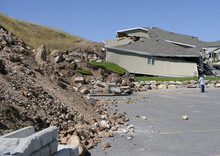
That is welcome news for residents of North Salt Lake's Eagleridge development, where public safety crews kept close watch on a landslide that on Tuesday destroyed one home and forced evacuation of more than two dozen others. Drier weather also will be welcome respite for some 100 homeowners who continued Wednesday dealing with the aftermath of flooded basements and muddy streets in Emery and Carbon counties.
The Wasatch Front looked for waning, isolated showers and thunderstorms Wednesday and through much of Thursday. However, by dawn Friday, the drying trend will kick in.
High temperatures were to range in the upper 70s to low 80s in the Salt Lake and Tooele valleys on Thursday, echoing Wednesday's forecast.
In southern Utah, Thursday's forecast called for highs in the mid-90s under sunny skies — a repeat of Wednesday's predictions.
Only Salt Lake and Weber counties were rated "yellow," or compromised for air quality on Thursday. The Utah Division of Air Quality rated the rest of the state as "green," or healthy.
The Intermountain Allergy & Asthma website listed only mold as "high" while chenopods were at "moderate" on its pollen index as of Wednesday.
Visit the Tribune's weather page (http://www.sltrib.com/weather) for more extensive, localized forecast content.
Twitter: @remims